Breckenridge Hills, MO Our History
The history of Breckenridge Hills is basically a story of the land and the people who have settled her over the years. We have been able to trace some, but not all. The problem had been one of tracking very old records.
In many cases the material is sporadic. However, with the generous help of very kind people we have begun a history of the area. As any beginning we realize it is not a complete and comprehensive history of the area, but it is a start.
It is our hope that all those who have further historical information on the community and the land will bring it to the attention of the (Breckenridge Hills Officials) so future groups will have a more complete record of our community.
Acknowledgments:
(The compiling of this information) would have been impossible without the generous help of (former) Police Chief Donald Sweeney, Donald Wander, Willaus Carter and Lon Wadman. These gentlemen gave tirelessly of their time, skills, and information.
OWNERSHIP OF THE LAND
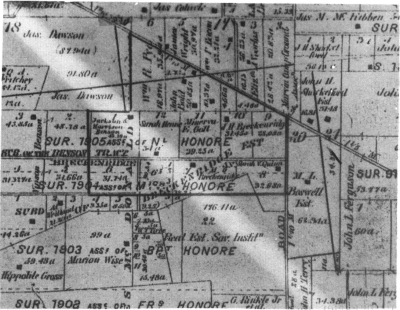
The land which occupies the boundaries of present day Breckenridge Hills can be traced back to the late 1700's. A Canadian named Louis Tesson Honore, Sr., who was living in Daskaskia, Illinois at the time, received one of the initial Spanish land grants in this area in the 1770s.

Louis Tesson Honore, Sr. and his wife, Magdalena Peterson, had eight children, on of whom was Noel Honore, who owned much of the land now known as Breckenridge Hills. Another son, Michael Honore, also owned a small portion of land in what is now the southwest corner of Breckenridge Hills.
It is interesting to note how much of the property in this area has been passed on from person-to-person and family-to-family up to the present time.
For example, the land on which the Breckenridge home was erected, was officially granted by the U.S. Government to Noel Honore with James McDonald, as an associate and overseer of the property, in 1803, after the Louisiana Purchase. The home still stands at 3343 Edmundson Road. In 1821 this land was willed to Arch McDonald. The property was owned by Arch McDonald for only eight years when it was again transferred to James Breckenridge, whose family played a very important role in the formation of this small community, which later was named after the Breckenridge family.
James Breckenridge moved here from Kentucky in 1821 with his wife Eve, their two sons, John and Issac and their daughter, Elizabeth. Upon James' death in 1858, his property was passed to his son Issac. Isaac owned the land for 22 years when he transferred ownership to Mr. N. D. Allen. Because of taxes, Allen lost the property in 1883, whereupon it was granted to John Breckenridge, James' other son.
In 1908, John donated his property to the Missouri Baptist Home, who maintained ownership until 1923 when it was sold to the Reasor family. After only four years Mr. Rasor sold the site to a Mr. Heiman, who lived there for 20 years. In 1947, Mr. Heiman sold the land to Mr. Zander, who also kept the land for 20 years at which time it was subdivided and sold to a Mr. Amboro and various others in 1967. The Gipson family purchased Mr. Ambro's property in 1971.

Another portion of land originally owned by the Honore family is the area on the west side of what is now Sims Avenue. This land was held by Noel Honore and James McDonald until 1831 when it was sold to a man by the name of Benson. Mr. Benson lived here for 75 years, when in 1906 he sold to a Mr. Miller on a quick claim, which is similar to a transfer of land. This land was sold three times during the year 1906.
On November 17, 1906, Mr. Miller lost the property due to foreclosure to a man named Reese. Just two days later on November 19, 1906, Resse sold the ground to Mr. Stormer, who kept it until August of 1909 when Carrie Investment Company purchased the land. Carrie Investment then sold the land to Wanstrath Realty Company, in 1916. Two years later Wanstrath Realty sold to Mr. Graham, who only one year later also sold on a quick claim to Mr. Goeke. This property had seven different owners between 1906 and 1920. In 1920, the land was purchased by Mr. Peter Fath who owned the property for quite awhile, when he decided to subdivide it and sold all but the ground on which he resided at 3107 Sims Avenue.

As stated previously, in the 1800's, the Breckenridge (also spelled "Brackenridge") family played a very important role in the early establishment of this community. James Breckenridge's daughter, Elizabeth, having been widowed three times previously, married Frederick Hyatt. The Hyatt's owned a piece of land in the area which had been part of the Noel Honore estate.

Frederick became a very influential man in the community, being a Whig, a Justice of the Peace, a tax collector and a judge of the county court.
Hyatt died in 1870, leaving Elizabeth a widow for the fourth time. Elizabeth sold her plot of land to Minerva E. Goll sometime prior to 1878.
Goll later sold this property to a family by the name of Foster. Isaac Breckenridge, Elizabeth's brother, also owned to tracts of land to the east of the Hyatt property.
Other prominent names in the history of Breckenridge Hills are Lois Breckenridge, Isaac's wife and their five children. Elizabeth, their only daughter, died when she was still in her teens; Erastus, also died while very young; James, died at the age of 26; John lived until 1907 and Thomas died in 1910, at the age of 75. This entire family is buried at the Fee Fee Cemetery.

Other land owners in the area about whom very little is known is Asa Breckenridge, who owned land to the south of the Hyatt property and the Issac Breckenridge property. Sarah Quinn who owned land east of Asa Breckenridge, which sometime between 1878 and 1909 was transferred to the Boswell family, and the Humes, who property was to the west of Hyatt's land.
The above encompasses only a portion of this area, but illustrates how the beginnings of this (city) coincided with the beginnings of Saint Louis itself and can be traced back to one of the earliest settlers in Saint Louis, Louis Tesson Honore, Sr. This brief history of the land shows the transfer of property for the past 200 years to become what it today, Breckenridge Hills, Missouri.
THE TRAIL WEST
The original Saint Charles Road followed an Indian trail to the Village of the Missouris.
According to Louis Houck's history, the road, which was granted by the Spanish King, who was proprietor of the Domain (what is now the Missouri area), was used mainly to accommodate people to whom he had made grants of land west of Saint Louis.
The first information of a road connecting Saint Charles and Saint Louis was the old Spanish Road laid out in 1772 when Saint Charles was a wilderness.
General Victor Collot's map of the Country of Illinois, dated 1796, shows the Saint Charles Road leading from the Saint Louis Stockade through the Saint Louis Common fields and Grand Prairie Common fields on the banks of the Missouri River opposite of Saint Charles. Two road spurs went to the north, the first connecting with what is now Florissant and the second with what is now Bridgeton.
About 1817, the settlers using the road west were mostly from Kentucky and Tennessee. During October of that year, no less than 270 wagons and four-wheeled carriages, and 50 two-wheeled carriages and carts passed along the road, taking not less than 3,000 person into Saint Charles County. It was estimated that some 12,00 settlers preceded them at a rate of about 20 wagons a week for a period of nine or ten weeks.
In front of the DeHart Mansion at Isolda Avenue and Saint Charles Rock Road, as it is known today, was a "12 Mile House". Food and drink were available to the travelers from Saint Louis to Saint Charles as well as water, food and rest for the horses.
Saint Charles Road in 1819 was established as a post and stage road. If we would listen we might be able to hear the old wagons and horses traveling along either for pleasure, business or many, many times matters of State.
It was not until August 9, 1834, that the court declared the road a public highway from the Catholic Grave Yard to the ferry on the Missouri River opposite of Saint Charles. The road proceeded next along what is now known as Franklin Avenue, pas the Saint Louis City limits which ended at Carr Square and continued along Easton Avenue past what is now Wellston, Missouri on what is now known as Saint Charles Rock Road in a continuous trail to the ferry on the Missouri River opposite Saint Charles.
In the early 1830's, records mention Saint Charles Road passing through what is now Breckenridge Hills. "Beyond the Governor Miller place Saint Charles Road ... cross Cold Water Creek, when by the place of James Brackenridge."
Saint Charles Road did not cover the route it does today as it passes through Breckenridge Hills, but took a route that passed over what is now Burton Avenue and past the Brackenridge house which is now located at an odd angle at 3343 Edmundson Road. It also went on Foster and Benson Avenue and through what is now Saint Ann. It continued on past Fee Fee Cemetery to the Missouri River.
In 1837, the Road was incorporated and became a Turnpike. It was to be kept open at least eighty feet wide and twenty-four feet would be macadamized.
The company would be permitted to erect three toll gates. The rates were not to exceed the following:
For each man and horse 6 1/2 cents
For each loose horse 4 cents
For each four wagon team 30 cents
Each pleasure carriage 30 cents
Each head of cattle 2 cents
Each sheep, hog or other animal 1 cent.
In 1865 a petition was filed with Saint Louis County Court indicating in that year the entire road between Saint Louis and the Missouri River opposite Saint Charles had been constructed of rock. After this improvement the highway was termed "Saint Charles Rock Road".
The road as designated then ran form Saint Louis to Saint Charles by way of Elleardsville Post Office, Cote Brilliants Settlement, Rinkelville Post Office, Camp Marvin and Hartville. All of these post offices and settlements have passed into history and in their places have sprung up the communities of Wellston, Breckenridge Hills, Saint John's Station, Pattonville, and West Lake Park.
Another old landmark in Breckenridge Hills is the DeHart Mansion. (The mansion, after years of neglect, was torn down and removed, being replaced by the current Hickory Trace Apartment complex.) The mansion pictured here:

was a lovely example of a building of the 1800's. A point of interest is that the DeHart family had numerous farms beside the one in Breckenridge Hills. One of special interest owned by them was sold to the City of Saint Louis for the first land acquisition of the Lambert Airport.
Under the Hayes Road Law, the Saint Charles Rock Road became the first concrete state highway in Saint Louis County and one of the first and longest stretches of state roads in Missouri Developed under the State Highway Department.
Concreted from Wellston to Saint Charles, a distance of about twelve miles, at a cost of $600,000.00, the improvement was completed in 1921.
At the turn of the century, trolley cars came into existence on the Rock Road. On January 17th, 1932, the Saint Charles Line west of Edmundson Road was discontinued. The tracks ran along the north side of the Rock Road. The western terminus loop was near Edmundson Road after 1933. From 1933 until December 28th, 1949, rush-hour service on the street car was available. Today the sound of the street car has become a pleasant memory of the past (replaced with a Metro Link line which has a station some five miles east of Breckenridge Hills, on Saint Charles Rock Road).
Today the portion of Saint Charles Rock Road that passes through Breckenridge Hills is much wider than it was in the early 1800's. The road has been straightened out and widened. It no longer passes the Breckenridge house or winds its way out to Fee Fee Cemetery. People do no have to stop at toll gates or watch for horses, sheep or hogs. They don't have to watch for the street cars as they drive through the (city) at 35 miles-per-hour.
THE BLACK COMMUNITY
"Paranoia reached its height when in 1835 the Missouri General Assembly cites its constitutional authority to 'pass such laws as may be necessary...to prevent free negroes and mulattoes from coming to and settling in this state under any pretext whatsoever."
In 1856 when the slavery controversy was at its height, laws were passed which required "all negroes to be in their quarters by nine o'clock." Despite the rigid laws and restrictions of this period, a young black man named Washington Reed came to Missouri to the area which is now Breckenridge Hills. This young man has left a proud heritage to his family and to the (community as a whole).
Washington Reed left his home in Racine, Wisconsin sometime during the 1850's. He spent three years before the Civil War renting and farming lands in the Breckenridge Hills and Overland areas.
Reed enlisted in the Union Army on October 17th, 1863 at Providence, Rhode Island. He served as a Sergeant in "G" Company of the 11th Regiment, United States Colored Artillery. Sergeant Reed fought until the end of the war and was discharged in New Orleans, Louisiana in 1865.

He then returned to Missouri and married Miss Belle Lackey. They had seven children, two sons; Alonzo and Logan, and five daughters; Elizabeth, Carrie, Maude, Mamie, and Stella.

Over the years, after the war, the Reed family worked rented farms, operated a dairy and Mr. Reed also taught the black children (in the community).
A section of the Breckenridge Estate was auctioned at the County House in 1889. Reed, through a great deal of hard work, had amassed enough to pay $125.00 an acre for 44 acres of land bounded by present day Baltimore Avenue, West Milton Avenue, Breckenridge Avenue and Quiet Lane.
The original home of the Reeds was located on the South East corner of what is now Rex Avenue and Breckenridge Road. Sergeant Reed died in 1915 leaving his property to his widow, Belle.
Upon the death of Mrs. Belle Reed, the land was passed on to the Reed children. All of the children except Carrie Reed Carter had subdivided and sold their holdings between 1948 and 1950.
Breckenridge Hills is one of the few communities that can boast of a family which has owned land and maintained a fine community for over a hundred years.
A great deal of gratitude is owed to Sergeant Washington Reed, his descendants and to all members of the black community for the heritage and service given to the Breckenridge Hills community.
SCHOOLS
In 1846 the first school of the present day Ritenour School District was erected. White children of school age who wanted to attend public school would have been found in this building known as the "Buck Schoolhouse", which was located on Woodson Road near Lackland Road. Members of the black community were not allowed to be educated until after the Civil War. In 1867, a school for the black children was started at a site on Lackland Road and Sims Avenue.
The white children attended the various schools near their homes which were erected over the years. DeHart School which opened in 1948 was the only elementary school within the actual boundaries of the City of Breckenridge Hills. (It stood on the corner of Saint Charles Rock Road and Wismer Road and was replaced by a bank.) Elmwood School replaced the original black school and served as an elementary educational facility for black children until the integration of the public schools.
Ritenour High School which opened in the fall of 1950 also stands within the City of Breckenridge Hills School. (As part of their routine patrol work, two officers of the Breckenridge Hills Police Department are assigned at the High School during regular school hours. With an enrollment well over a thousand students, Ritenour High School becomes a small city within a city.)
Although the area did not require a great many schools for its population, certainly the citizens of Breckenridge Hills were active in the Ritenour educational system. Sergeant Washington Reed served as a teacher of the black school, and J. P. Breckenridge was clerk of the District during the years 1884 and 1893.
INCORPORATION
The land called Breckenridge remained as mainly a residential community over the years. Part of the area, along Woodson and Edmundson Roads was incorporated as part of Uniondale on December 3rd, 1915. The incorporation was short lived because in October, 1919 the citizens voted to disincorporate.
There was no further attempt at local government for the area until the Spring of 1942 when Overland voted to annex all the Community Fire District which included the Breckenridge area. The citizens of the unincorporated area were stunned by the action since they were not residents of Overland and therefore not entitled to vote on the decision to be annexed. An organization called the 'Ritenour Protective Association' campaigned vigorously and slipped into office in the April 1943 elections. Mr. Herbert Locke of the 4th Ward was the representative from the Breckenridge area. The new board of alderman held a special referendum on July 6th, 1943. Voters approved the deannexation of the incorporated areas from Overland by an overwhelming majority. The aldermen had put themselves out of a job in three months.
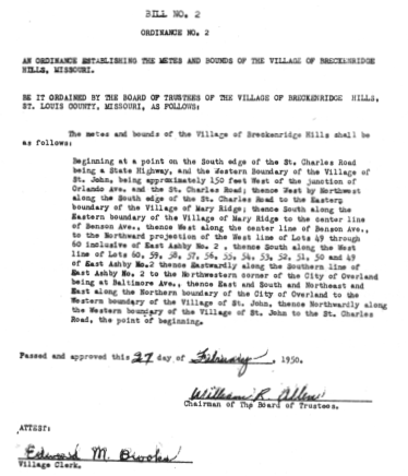
In 1950 Breckenridge Hills incorporated as Saint Louis County's eighty-first municipality. There still seems to be some doubt in the minds of many residents as to how incorporation actually took place. The court appointed Board of Trustees (W.R. Allen, L.M. Brooks, J.K. Stutes, W.T. Rabenneck and J.L. York) held the first meeting on February 27th, 1950 in the Hope Lutheran Church. Three ordinances were passed at this meeting; the name of Breckenridge Hills was chosen, the boundaries of the then called village were set and laws governing elections were established.
The first 'village' elections took place on April 4th, 1950. The first elected Trustees were Marvin Moutrie, Clarence Fritz, Harvey Oliver, Vincent Ballman and Walter Clark. At the third meeting of The Village of Breckenridge Hills on April 12th, 1950, Mr. Oliver was named the first 'Village Marshall'.
Problems persisted for the next two years. In the April, 1952 elections none of the twelve candidates received enough votes to be elected. However, five write-in candidates did receive a majority vote. The Board refused to seat the five 'write-ins', declaring them illegal. The problem was taken to the courts. The 'write-in' Trustees were seated only to be ousted at a special election held in December, 1952.
After these original difficulties the 'Village of Breckenridge Hills' settled into a period of steady growth and improvement. In 1953, due to increased population, the number of trustees was increased to nine. Also that year, The City Hall, which was originally held at 9766 Saint Charles Rock Road, was moved to 3313 Woodson Road. On December 8th, 1957 was moved north to 3120 Woodson Road. In April 1993, the city hall moved back onto the Rock Road in the office building at 9623 Saint Charles Rock Road.
In April 1990 the 'Village' of Breckenridge Hills became the City of Breckenridge Hills when the charter was amended in order for the community to take tax and grant money advantages. The charter changed the at-large trustee system to an elected Mayor and the establishment of the four ward city council system still in use today.
Over the years the city streets have been improved, street lighting, storm water drainage, and a sewer system have been installed and improved. To this day, garbage service is still a benefit of living within the City of Breckenridge Hills and is paid for by the city. Most recently the Breckenridge Road creek bridge as well as bridges on Marvin Avenue, Coles Avenue and Edmundson Road have been replaced in an effort to streamline the creek and the flooding that sometimes occurs.
FUTURE
Due to the expansion of nearby Lambert International Airport, a lot of changes may soon be coming to both the business district as well as the residential area of Breckenridge Hills.
The above edited information was previously published in a 1976 pamphlet for the U.S. Bicentennial entitled "TRAILS WEST" commissioned by the Breckenridge Hills Bicentennial Committee.
"TRAILS WEST" was written and compiled by Carol Boyd, Marge Stolte, Carole Vorst, and Donald Sweeney. Photographs were provided by Lon Wadman.
If anyone has any additional information, photographs, etc. and would like to provide them to this brief history of Breckenridge Hills please call city hall or email: webmaster@breckenridgehills.org.
Some information previously published has been updated and/or omitted. Updated information has been compiled by Officer Jim Garrison of the Breckenridge Hills Police Department. Recent photographs were taken by former City Council Member Judy Gassmann. Our heartfelt thanks to everyone who has helped with this history!